Tierra del Fuego National Park Guide: Trails, Train, Lapataia and Fees
Plan Tierra del Fuego National Park: trails, the End of the World Train, Lapataia Bay, entrance fees, buses from Ushuaia, and half vs full-day visits.
By Patagonia Tourism Guide · First published 26 Aug 2026 · Updated 1 Aug 2026
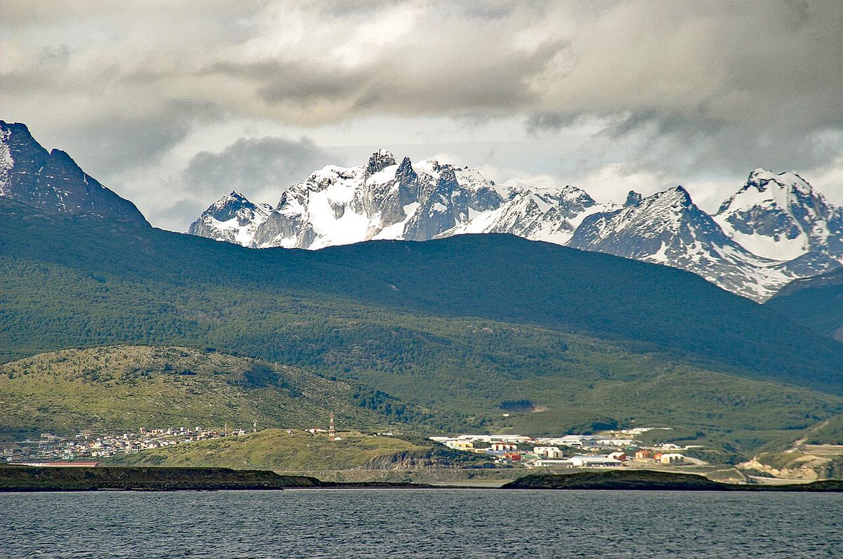
0 — 2 km Fig. 1 · Forest, bay and mountains in Tierra del Fuego National Park near Ushuaia · Photo: User:IlyaHaykinson / CC BY-SA 1.0 via Wikimedia Commons
You can stand at the end of Argentina here. Ruta Nacional 3 runs the length of the country and simply stops at a wooden sign on the shore of Lapataia Bay, where the forest, the mountains and the cold green water of a fjord all meet at once.
That sign gets the photos. The park behind it is the reason to stay.
Tierra del Fuego National Park is a 68,909-hectare reserve 12 km west of Ushuaia where Patagonian forest meets the Beagle Channel, the only national park in Argentina that mixes marine, forest and mountain country in one place. You can see the highlights in a half day, or hike, ride the End of the World Train and visit Lapataia Bay across a full day. This guide is for anyone planning that visit, whether you have three hours or a whole day, a rental car or a seat on the bus from town.
It is the dedicated national-park companion to our wider Ushuaia and Tierra del Fuego travel guide, which covers the city, the Beagle Channel and how the far south fits a larger trip. Here we go deep on the park itself: the trails, the train, the fees, and how to spend your time.
Tierra del Fuego National Park at a Glance
Here is the fast version, so you can see the shape of a visit before reading the detail. All distances and times come from the park’s own trail descriptions.
Trail
Distance / time
Difficulty
Season / best for
Mirador Lapataia
980 m / 30 min
Easy
All year. Quick fjord-and-bog viewpoint
La Baliza
1.2 km / 30 min
Easy
All year. Short coastal walk from Lapataia
Paseo de la Isla
1.3 km / 30 min
Easy
All year. River-island loop, family-friendly
Castorera
Short / ~20 min
Easy
All year. Forest walk to an old beaver dam
Senda Costera
8 km / 4 hr
Medium
Nov–Apr. The classic coastal hike
Hito XXIV
3.5 km each way / 3 hr round trip
Medium
Nov–Apr. Lakeshore walk to a border marker
Pampa Alta
4.7 km / 2 hr (+252 m)
Medium
Nov–Apr. Forest route with a viewpoint
Cerro Guanaco
6 km each way / 4 hr up (+900 m)
Hard
Nov–Apr. Big-view summit, registration, last entry 12:30
Swipe to see all columns
Table 1
If you only have a half day, do Lapataia Bay, a couple of the short boardwalk trails, and the Lago Acigami viewpoint. With a full day, add the Senda Costera or Cerro Guanaco, or pair a short visit with the End of the World Train. The park is open roughly 08:00 to 20:00, and there is no cell signal, internet or grid power anywhere inside, so plan around that.
Where It Is and How to Get There
The park sits 12 km west of Ushuaia along Ruta Nacional 3. The first half of that road is paved; the second half, and all the roads inside the park, are gravel. It is close enough that you can be walking a trail 30 to 40 minutes after leaving your hotel.
You have four realistic ways in.
By regular bus from town
The simplest car-free option is the scheduled minibus service that leaves central Ushuaia at set times through the day. The official provincial tourism board notes these regular lines run on fixed departures and make six stops inside the park, so you can get off at Lapataia, walk, and catch a later bus back. Our Ushuaia and Tierra del Fuego guide lists the usual pickup points on Avenida Maipú and Juana Fadul. Buy a round trip, confirm the last departure from the park, and do not miss it, because there is no taxi rank waiting at Lapataia.
By taxi or remis
A taxi or remis gives you flexibility without driving on gravel yourself. You can arrange a drop-off and a pickup time, or hire a driver to wait. It costs more than the bus but less than a full guided tour, and it suits travelers who want to walk at their own pace.
By rental car
A car is the most flexible choice. You can stop at every viewpoint, move with the weather, and reach the trailheads at Ensenada Zaratiegui, Lago Roca and Río Pipo on your own schedule. Two things to know: the internal roads are narrow, winding, dusty gravel with a 40 km/h speed limit, and in winter snow tyres or chains are obligatory. Drive slowly and watch for foxes, geese and birds on the road.
By guided tour
An organized tour handles the logistics, adds interpretation, and often bundles the End of the World Train. It is the easiest way to see the park in a fixed window, especially before an Antarctica cruise when you do not want to think about transport. The trade-off is pace; you move with the group, not the light. For deciding whether the park belongs in a packed schedule at all, the Patagonia itinerary planner puts the far south in context.
Tierra del Fuego National Park Entrance Fee and Tickets
Fees change with Argentina’s economy, so treat every number here as a guide and confirm on the official park fee page close to your visit. Bring your passport, because the price depends on your visitor category.
As of the June 1, 2026 update to the Argentina National Parks fee schedule, daily access (Pase diario) to Tierra del Fuego was listed at around ARS 40,000 for the general category, ARS 18,000 for Argentine nationals, ARS 8,000 for provincial residents, and ARS 12,000 for students. There are also Flexipass options: a 3-day pass at around ARS 80,000 general and a 7-day pass at around ARS 140,000 general, plus a national-parks annual pass.
A few practical points the fine print actually matters on:
Second-day discount. Every fee-charging Argentine park gives a 50% discount on a second day’s visit within 72 hours of your first entry. For Tierra del Fuego specifically, that discount applies only to tickets bought online through the official sales portal, not at the gate. If you plan to come back the next day, buy online.
Who gets in free. Children aged 0 to 5, retirees and pensioners, people with disabilities, local residents, educational school visits, national-parks staff, accredited guides, and Malvinas war veterans are exempt. Each category needs the right documentation.
Check what your tour includes. “National park tour” prices may or may not include the entrance fee, and almost never include the train. Ask before you pay.
Cash and connectivity. There is no cell coverage inside the park, so sort your ticket before you lose signal. Buying online in advance is the safest move in peak season.
Older travel pages, and even one official tourism page, still describe the park as free entry. That is out of date. Tierra del Fuego charges access, generally between mid-September and the end of April.
Best Trails in Tierra del Fuego National Park
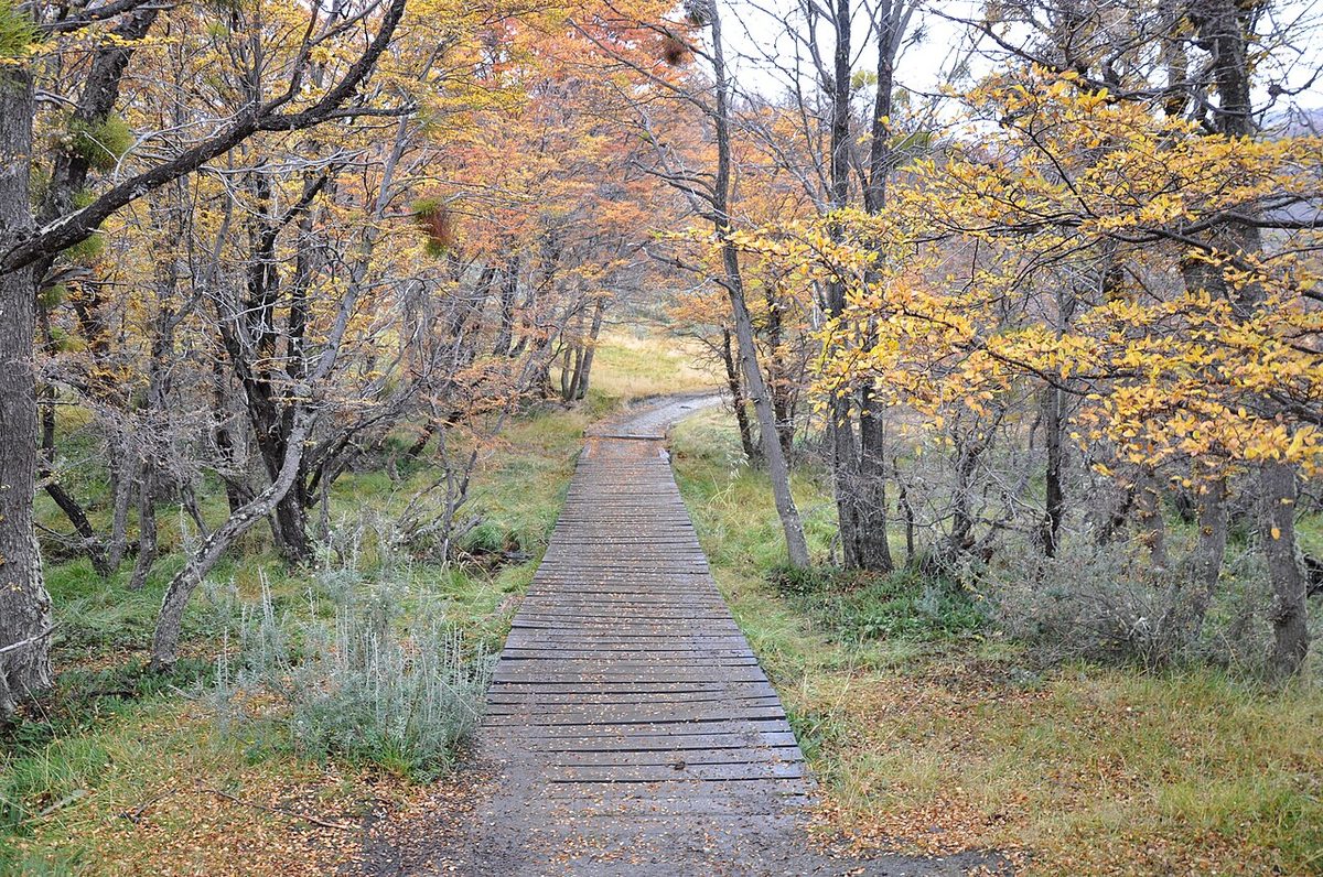
The park has a marked network of about 40 km of trails, roughly eight short and easy walks plus four or five longer, more demanding routes. You do not need to be a mountaineer to enjoy it. Some of the best bits are flat boardwalks over peat bog with the Beagle Channel right there.
Let me split them the way I actually think about them: short walks anyone can do, and bigger hikes worth a full day.
Short walks (under an hour)
These are the ones to string together on a half-day visit. All are open year-round unless noted.
Mirador Lapataia — 980 m, about 30 minutes, through forest and peat bog to a viewpoint. The quickest way to understand the landscape.
La Baliza — 1.2 km, about 30 minutes, starting from the Bahía Lapataia boardwalks through coastal forest, grassland and shore. The marker (baliza) flags the edge of the Strict Nature Reserve, which you cannot enter.
Paseo de la Isla — 1.3 km, about 30 minutes, a gentle loop through river-island and forest country. Good for families.
Senda del Turbal — 1.35 km, about 40 minutes, across classic peat bog. It shares its parking and first stretch with Mirador Lapataia, so you can combine them.
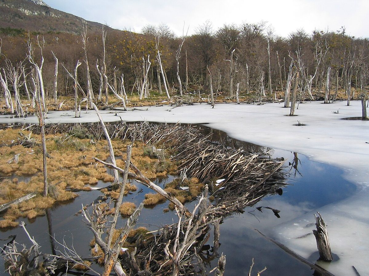
Castorera — a short forest walk off Ruta 3 to an old beaver dam, with an interpretive, partly accessible section. A neat introduction to the park’s beaver story.
Cascada Río Pipo — 900 m each way, about 15 minutes, from the Río Pipo campground to a waterfall. Open November to April.
Bigger hikes (half day or more)
For these, carry layers, food, water and an offline map, and check current trail status before you go. Some require registration on entry and exit.
Senda Costera — about 8 km, 4 hours, medium difficulty, open November to April. This is the classic. It runs the coast from Ensenada Zaratiegui to the Lago Roca road near the Alakush visitor centre, hugging the marine shore most of the way. If you do one real hike here, make it this one.
Hito XXIV — about 3.5 km each way, 3 hours round trip, medium, November to April. From the Lago Roca/Acigami parking it follows the lakeshore to border marker XXIV, near the Chilean frontier. Easy underfoot with very little elevation, and a lovely lake walk.
Pampa Alta — about 4.7 km, 2 hours, medium, November to April, with around 252 m of climb between Ensenada and the Río Pipo area. A forest route with interpretive signs and a viewpoint.
Cerro Guanaco — about 6 km each way, 4 hours to the summit, high difficulty, with 900 m of gain, open November to April. This is the park’s big payoff hike, climbing from Lago Roca through forest and peat bog into high-Andean terrain. It needs mountain experience, proper footwear and clothing, and the park sets a maximum entry time of 12:30 so you are not caught out by dark or weather. Register before you start.
Laguna del Caminante — about 24.4 km, 9 hours, high difficulty, December to March. Note that both trailheads sit outside the park, in the Andorra and Cañadón de la Oveja valleys within Ushuaia municipality. There is avalanche risk while snow lingers on the peaks, so the park advises checking conditions daily with provincial Civil Protection. No-fire camping is allowed at the lake. This is a serious mountain day for experienced hikers only.
The End of the World Train, the Tren del Fin del Mundo, is the most famous single experience attached to the park, and the question I get most is whether it is worth the money.
Here is what it actually is. The narrow-gauge steam-style railway departs from a station about 2 km before the park entrance gate, then runs roughly 7 km bordering the Río Pipo, passing the Cascada Macarena, a stretch of cut stumps known as the tree cemetery, and a stand of lenga forest, before reaching the Park Station inside the boundary. It recreates part of the historic railway that Ushuaia’s penal-colony prisoners built and used in the early 1900s to haul timber, which is where the prison-history theme comes from.
So is it worth it? My honest take:
Yes, if you are traveling with kids, you love scenic heritage trains, you want an easy, narrated park day, or the prison-colony history interests you. It is genuinely charming and the backstory is real.
Probably not, if you are a hiker with one day and a tight budget. The train ticket is separate from park entry and is not cheap, and the same hours spent walking the Senda Costera will show you far more landscape.
One logistics note: the train drops you inside the park, and you can continue your visit independently or by tour bus from there, but if you do not have your own vehicle you need to plan the return transfer. Do not assume the train round trip alone covers the whole park.
Lapataia Bay and the End of Ruta 3
If the park has a heart, it is Lapataia Bay.
This is where Ruta Nacional 3 ends, 3,000-odd kilometres from Buenos Aires, at the famous wooden sign marking the end of the road. It is also the only fjord on the Argentine side of the island, a quiet inlet of the Beagle Channel ringed by forest and bog. The short boardwalk trails here, Mirador Lapataia, La Baliza, Paseo de la Isla and Senda del Turbal, all start within a few minutes of each other, which is why this corner is the obvious base for a half-day visit.
Take the photo at the sign. Everyone does, and it is a good one. Then walk one of the boardwalks out over the peat bog or along the shore, and you will understand why this is more than a roadside marker. On a still morning, with the water flat and the lenga forest coming down to the edge, it is one of the calmest places in Patagonia.
Nearby, Lago Acigami, which you will also see labelled Lago Roca, is the big binational lake straddling the Argentina-Chile border (it becomes Lago Errázuriz on the Chilean side). The viewpoint and the Hito XXIV trail both start from its shore, and there is a visitor centre with a café-restaurant at Alakush if you need a warm-up.
Wildlife, Forest and Peat Bogs
The park is a real ecological crossroads, and slowing down to notice it is half the point.
The forest is southern beech country: lenga, guindo, canelo and ñire. In autumn the leaves turn deep red and ochre, and it becomes one of the most photogenic forests in the south. Between the trees you cross peat bogs, turberas, which are not empty brown ground but fragile, slow-growing wetlands. Stay on the boardwalks and marked trails; if a path is muddy, walking through it does less damage than widening it.
For wildlife, the park’s own symbol is the upland goose known locally as the caranca, or cauquén caranca. You may also spot the marine cauquén, black-browed albatross, the flightless steamer duck, the giant Magellanic woodpecker, and the Patagonian thrush. Among mammals, look for the Fuegian red fox and, if you are lucky and quiet near water, the huillín, a southern river otter.
One animal you will see the evidence of everywhere is the beaver. Beavers were introduced from Canada in the 1940s for a fur trade that never really worked, and with no natural predators here they became a serious invasive problem. Their dams flood and kill large stretches of native forest, and the drowned grey trees along the valleys are their handiwork. The Castorera trail leads you to one of these old dams and explains the story. It is a strange, instructive thing to see: a beautiful structure that is quietly wrecking the forest around it.
There are deep human roots here too. The Yaghan people lived along these shores for thousands of years, and the shell middens, concheros, scattered through the park are physical evidence of that long presence. The “End of the World” branding is catchy, but this place was never empty.
How long you need depends entirely on whether you want to walk or just look. Both are valid.
The half-day visit (3 to 4 hours)
This is the right call if you are pairing the park with a Beagle Channel cruise the same day, or if you simply want the highlights without a big hike. A workable shape:
Enter and drive or ride to Lapataia Bay.
Photograph the end of Ruta 3.
Walk two or three short boardwalks (Mirador Lapataia, La Baliza, Senda del Turbal).
Stop at the Lago Acigami viewpoint and the Castorera on the way back.
You will see the marine-forest-mountain mix, get your photos, and be back in town for lunch or an afternoon boat. It is a sampler, not a deep dive, and that is fine.
The full-day visit
A full day lets the park breathe. Two good versions:
Hiker’s day. Drive to Ensenada Zaratiegui and walk the Senda Costera (about 4 hours) to the Lago Roca road, or tackle Cerro Guanaco if you are fit and start before the 12:30 cut-off. Add Lapataia and a short walk afterward if you have energy.
Easy-going day. Take the End of the World Train in, explore Lapataia and the short trails, have lunch at the Alakush café, and drive the viewpoints at a slow pace.
If the park is the main reason you came to Ushuaia, give it a full day. If it is one of several things on a tight schedule, the half day covers the essentials honestly. For fitting it all together across two or three nights in town, see our sample plans for Ushuaia and the wider list of things to do in Ushuaia.
Camping and Registration Rules
The park has four wild, basic (agreste) campgrounds, and the rules matter.
According to the park, the camping areas with chemical toilets are open roughly November to April: Río Pipo, Ensenada, and Laguna Verde/Cauquenes. None have other services, so come fully self-sufficient. The exception is Laguna del Caminante, deep on the long trek, which has no toilets at all and sits about eight hours’ walk from the trailhead.
Two rules to plan around:
Registration. Camping registration has been mandatory through an online form, and several trails require you to sign in on entry and exit. Cerro Guanaco needs prior registration. Always check the current requirement before you go, because there is no signal in the park to sort it on arrival.
Fire. Open fires are banned. Stoves and any combustion equipment are allowed only within the designated camping areas. On the Laguna del Caminante trek, only no-fire camping is permitted at the lake.
If you are camping, also remember the winter closures: from roughly May to September, access to Ensenada Zaratiegui and the Río Pipo campground is closed. For broader logistics on tents, stoves and cold-weather camping across the region, the backcountry safety basics goes into detail.
What to Bring
The weather here turns fast, and the park has no shops, no electricity and no phone coverage. Pack as if you are self-sufficient for the day.
Windproof and waterproof outer layer.
Warm mid-layer, plus a hat and gloves even in summer.
Footwear with traction that you do not mind getting muddy; the peat bog and gravel are unforgiving on clean shoes.
Water and snacks or a packed lunch.
Sunglasses and sun protection, which people forget this far south.
An offline map downloaded before you arrive, because your phone will have no signal.
A power bank, since there is nowhere to charge.
Cash or a pre-bought online ticket for entry.
A dry bag or rain cover for your camera and electronics.
For Cerro Guanaco or Laguna del Caminante specifically, add proper mountain layers, a headlamp, and a realistic turnaround time. This is an accessible park, but it is still Patagonia, and the high ground takes the weather seriously.
Responsible Travel in the Park
This is a protected area doing a hard job, and a few habits keep it that way.
Stay on the trails and boardwalks, especially across peat bog, which recovers extraordinarily slowly when it is trampled. Take all your rubbish out; there are limited facilities and the park asks visitors not to leave anything behind. Pets are not allowed inside the park at all. Give wildlife room, never feed animals, and drive slowly enough on the gravel that you do not hit the foxes and geese that wander the road. Light fires only in the designated camping areas, never on the trails.
None of this is onerous. It is mostly about leaving the place exactly as you found it, which in a park this fragile is the whole point. For the bigger picture on travelling well in the region, see our overview of Argentine and Chilean Patagonia.
When to Visit
The park is open all year, but the season changes the experience.
December to March is the easiest window: long days, every trail open, and the most bus and tour frequency. This is the right choice for a first visit and for the longer hikes, which generally run November to April. Do not confuse summer with warm, though; it is cool even in January, and the weather can swing from sun to sleet in an afternoon.
April brings autumn colour to the beech forest and thinner crowds, with some services starting to wind down. The deep winter months, June to September, are a different park: parts close, including the Ensenada and Río Pipo access, snow tyres or chains become mandatory, and the focus shifts to the short, accessible corners near Lapataia. For matching your dates to the wider region, see best time to visit Patagonia, and for the city’s winter scene, our Ushuaia in winter guide.
How the Park Fits Your Ushuaia Trip
The national park is one of the two anchor experiences in Ushuaia, alongside the water. Most people pair it with a guide to the Ushuaia boat trips on a separate day, which gives you the land and the sea sides of Tierra del Fuego without rushing either. If you have a third day and like seafood, the king-crab village of Puerto Almanza, covered in our Puerto Almanza king crab guide, makes a good contrast to a park morning.
If you are still deciding whether the far south earns a place in a tight Patagonia route, that is exactly the question our Tierra del Fuego breakdown and the day-by-day Patagonia route plans are built to answer. And if you are coming from the other classic hiking hub, the El Chalten and Fitz Roy hiking guide sets the contrast: granite spires there, marine forest and bog here.
Tierra del Fuego National Park FAQ
How much is the entrance fee to Tierra del Fuego National Park?
Fees change with Argentina’s economy. As of the June 1, 2026 official update, daily access was listed at around ARS 40,000 for the general category, with lower rates for Argentine nationals, provincial residents and students, plus 3-day and 7-day Flexipass options. Check the official Argentina National Parks fee page close to your visit and bring your passport.
Can you visit Tierra del Fuego National Park without a tour?
Yes. You can visit independently by rental car, by taxi or remis, or on the scheduled minibus that leaves central Ushuaia and stops at six points inside the park. Buy a round-trip bus ticket and confirm the last departure. A tour mainly adds interpretation, easy logistics, and the option to bundle the End of the World Train.
Is the End of the World Train worth it?
It depends on your trip. The train is charming, family-friendly and rich in prison-railway history, and it makes for an easy park day. But the ticket is separate from park entry and not cheap, so dedicated hikers on a budget usually get more from spending those hours on the Senda Costera. Great for families, optional for trekkers.
How long do you need in Tierra del Fuego National Park?
A half day of three to four hours covers Lapataia Bay, the end of Ruta 3, a few short boardwalks and the Lago Acigami viewpoint, which pairs well with an afternoon Beagle Channel cruise. A full day lets you add the Senda Costera or Cerro Guanaco, ride the train, or simply explore at a slower pace.
What is the best trail in Tierra del Fuego National Park?
For most visitors the Senda Costera is the standout: about 8 km and 4 hours of medium walking along the marine coast from Ensenada Zaratiegui, open November to April. For a big-view summit, fit hikers choose Cerro Guanaco (6 km each way, 900 m of climb, registration required). For an easy taste, the short Lapataia boardwalks are hard to beat.
Is there an entrance fee discount for visiting two days?
Yes. Argentine national parks give a 50% discount on a second day’s visit within 72 hours of your first entry. For Tierra del Fuego specifically, that discount applies only to tickets purchased online through the official sales portal, not at the gate, so buy online if you plan to return the next day.
Can you see wildlife in Tierra del Fuego National Park?
Yes. The park’s symbol is the upland goose (caranca), and you may also see the giant Magellanic woodpecker, black-browed albatross, steamer ducks, the Fuegian red fox and, near water, the huillín otter. You will also see the damage from invasive beavers introduced in the 1940s, whose dams flood and kill the native forest.
Final Thoughts
The first time I reached the Lapataia sign I did the same thing everyone does: took the photo, grinned at the “end of the road” of it all, and then almost walked back to the car.
I am glad I did not. Five minutes onto the boardwalk, past the photo crowd, the park goes quiet. You get peat bog and beech forest, a fjord that belongs more to the sea than the land, woodpeckers hammering somewhere out of sight, and the strange grey skeletons of beaver-drowned trees. It is not the granite drama of Fitz Roy or the Torres. It is softer, wetter, stranger, and for the right traveler that is exactly the appeal.
So give it more than the sign. Walk a trail, ride the train if you have kids or a soft spot for old machines, sit by Lago Acigami for a while, and check the current fees before you go. Then fit it into the rest of the south with our guide to the end of the world and the Patagonia itinerary planner.